|
On May 21 - 24, 2004 my friend Casey, Everest, and I followed the Big Piney Trail through Mark Twain National Forest. I got a detailed topo map (Slabtown quadrant) from the ranger's office in Houston, Mo.
- Friday, May 21, 2004 -
5.5 miles
We started at the Roby Lake trailhead, and finally set out at 4:30 in the afternoon on Friday, May 21. The weather was just as it was forecast -- mid 80's, sunny, and humid. Lucky for us (especially lucky for Everest) most of our walk would be under trees. Unlucky for us, we would soon find out that water wasn't as plentiful as expected. And even though we ad been warned that the ticks were "really bad this year," they were a lot worse than we expected.
We started out on the South Loop and had planned on walking 3-5 miles on the first day. We ended up walking 5.5 miles on day one. Whereas I'm used to backpacking in the mountains where I can find good tent spot and water almost any time I'm ready to stop for the night, this area was quite different. The problem wasn't finding a good, flat spot. The problem was finding a flat spot that wasn't overgrown with poison ivy. Few, if any good tent spots were 100' from the trail. There should be plenty of good camping spots in the fall, winter, and early spring, but not late spring or summer. We ended up camping about two hundred yards short of the trail split that connects up with the North Loop.
The first day's hike started out in the open for about a quarter mile, then took us into the trees. We opted to start with the South Loop which, according to the map, offered a scenic area early on in the hike. There weren't any scenic points indicated on the North Loop until well past the six mile point. [We would later find that the North Loop does have some nice scenery, but not the sweeping vistas available on the South Loop.] The first scenic area was about 2.25 miles into the South Loop trail. Also right along the trail here were a few nice areas to camp. The ground here was covered in pine needles, and was not overgrown with poison ivy. But, because the trees were so full, there wasn't much of a view. I imagine this spot is very scenic in the fall, and offers a nice view in the winter (but not very colorful). Because we were so early in our hike, we decided not to camp here and continued on our way.
Over the next half mile, the trail dropped down to the creek. Unbeknownst to us, this would be the last place to get water today. Because the trail crossed in a dry spot, we had just stopped for a break, and the water was about 50 yards away, and a miscalculation of our water supply, we opted not to fill up with water. A mistake we would regret.
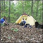
The last 2.5 miles of the day took us back uphill, and then flattened out. It was getting dark and we began to look for a place to camp. Because we were at the top of the hill we expected to find a clump of short leaf pines, similar to what we found at the scenic point, which would have made for a good camp site. We didn't find what we were looking for, and walked as far as the trail split before backtracking about 200 yards to the best site the area had to offer. We pitched the tent and cooked dinner, realizing then that our water supply was less than we thought. We used up all but 1/2 quart of our remaining water.
After dinner I brushed about 50 ticks off of Everest, and then we hung our food. We weren't concerned with bears, but weren't sure if we'd have other visitors ('coons, foxes, coyotes, etc.). And we hung our dirty dishes which had not been washed because of our lack of water. Friday night was a quiet night. We heard a few owls, but not much else.
- Saturday, May 22, 2004 -
9.5 miles
Saturday morning our primary concern was water. I gave Everest the last of the water onhand, then we debated going down the split to the creek to refill (we estimated about a mile roundtrip), changing our plans and completing Big Piney Trail in a figure eight, or continuing along the South Loop to the creek, an estimated 2.5 miles. Because the South Loop to the creek looked to be an easy 2.5 miles (flat/downhill), we opted to continue on the South Loop and just take it slow.
So we took it slow. We saw a box turtle on the trail (you mean these things actually live in places other than petting zoos?!) and encountered three other backpackers headed in the opposite direction. We then ran across a stony area that was perfect for a break. We munched some granola here and took some pictures, than continued down to the stream. Maintaining this slow pace, we never really missed the water. It probably help that our packs were that much lighter...
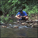
Upon arriving at the creek, we filtered & drank water, washed dishes, cooked pancakes (I discovered I lost a piece to my stove at last night's camp and my stove was now inoperable. Good thing Casey brought his), and washed dishes again. During the time here, we heard a tree creak, and after quite a few seconds, come crashing to the ground. Upon leaving the creek, we would find that the tree we heard fell across the trail about 50 feet from where we had breakfast. We also watched through the trees as eight other backpackers headed up the trail we had recently descended.
With our thirst quenched and our bottles full, we finally packed up and headed down the trail. We crossed the creek for the first time today and continued on for another mile before reaching the second crossing. Here we stopped for another hour or so, napped, and filled our bottles again. And because we were concern with running out of water again, we filled a couple of extra bottles and added them to our loads. A few Z's and a few pictures later, we were off again, hiking along a very overgrown trail and then uphill.
We encountered another scenic area as we approached the Big Piney Trail Camp, as well as a small pond. The area was scenic, but again the views were limited by the fullness of the trees. We also encountered a small pond before passing the trail camp.
Like the first night, finding a good camp on the second day wasn't an easy task. But, we did happen to find a nice area right at the time we had hoped to be able to stop. And, as luck would have it, we weren't too far from a filterable water source. Of course, we had carried extra water from the last creek and rationed it along the way, so we didn't really need the water that was available.
For dinner, we decided to give my Outback Oven (from Backpacker's Pantry) an initiation and cooked pizza. We had rehydrated the sauce and beef during the day, and packed in premade pizza crust and a block of mozzarella cheese. Although the sauce was too watery, it wasn't too bad.
Before going off to sleep, I brushed another 50+ ticks off of Everest. We opted to sleep without the fly on the tent as we woke up to a dry forest floor this morning. This proved to be a good choice, as there was no dew on Sunday morning.
- Sunday, May 24, 2004 -
5.5 miles
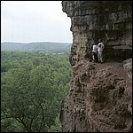
The trip back to the car wasn't especially scenic, but there were a few nice areas -- a pond, a spring, some nice rocky areas, and a few dry streams. Water was not especially plentiful. On the way to the car we encountered some horse riders jumping some downed trees, as well as one other backpacker (a woman headed out solo). After reaching the car and changing clothes, we set off to find the Slabtown Geocache (Geocaching.com). This cache is located very close to a cliffside cave that offered some spectacular views and photo opportunities.
- Summary -
The Big Piney Trail was nice. I can't say it was great, but this probably has more to do with the time of year (and quantity of ticks) rather than an deficiencies in the trail itself. Many of the streams we crossed were dry, and there were a hell of a lot of ticks! During the week after returning home, I pulled more than three hundred ticks off of Everest. This is not an exaggeration, I actually quit counting at three hundred, though I easily found another hundred over the next few days. We really didn't see a lot of wildlife. We heard some owls and some woodpeckers, encountered three box turtles on the trail, and saw the backend of a deer running away from us, but not much else. Admittedly, we didn't go looking (or sit quietly waiting for) wildlife, but I expected more. The trail has a nice balance of ups and downs, and is relatively easy to follow on the topo. We only encountered the three sets of other backpackers, so I can't say the trail is overly crowded. There is no doubt that the hike would have been more enjoyable in the off season, maybe just a month earlier, before the groundcover sprouted and before the ticks were out in full force.
That being said, I'm interested in revisiting the Big Piney Trail, perhaps in the fall when the leaves are changing. The scenic areas should be much more scenic then, and hopefully the ticks won't be as prevalent.
One final note about the ticks: Everest had been treated with Frontline two weeks prior to the trip, and still had quite a few that latched on, some of which inflated. Some did drop off, but more latched on than should have. Many of the ticks were tiny young ones, very difficult to find until they had inflated. I'm not sure why so many latched on. The Frontline I used was about a year old, but my vet indicated that this shouldn't have been an issue. I applied another dose of Frontline to Everest after returning, about three weeks after the first dose, and he still had a few that latched on.
|